This is the exact embedded text of the captured official document.
Snapshot 824bbec3fa06 · verified 2026-10-19 ·
original document ·
archived snapshot ·
unofficial consolidation, the official version is held by the municipal clerk.
# Zoning
The Municipality of Mississippi Mills Zoning By-law (Office Consolidation, April 2026) is a by-law that zones each property and permits specific uses; where buildings and structures can be located (e.g. setbacks); and how a site can be designed (e.g. required lot sizes, building heights, landscaping requirements, and parking requirements).
Zoning By-law
Amending By-laws By Year
Amending By-laws 2012
Amending By-laws 2013
Amending By-laws 2014
Amending By-laws 2015
Amending By-laws 2016
Amending By-laws 2017
Amending By-laws 2018
Amending By-laws 2019
Amending By-laws 2020
Amending By-laws 2021
Amending By-laws 2022
Amending By-laws 2023
Amending By-laws 2024
Amending By-laws 2025
### How to use the GIS Mapping Tool and Zoning By-law
GIS Mapping Tool
#### **Step 1: Find out what your property is zoned using the Municipality's GIS Mapping Tool.**
****
#### **Step 2: Determining required setbacks**
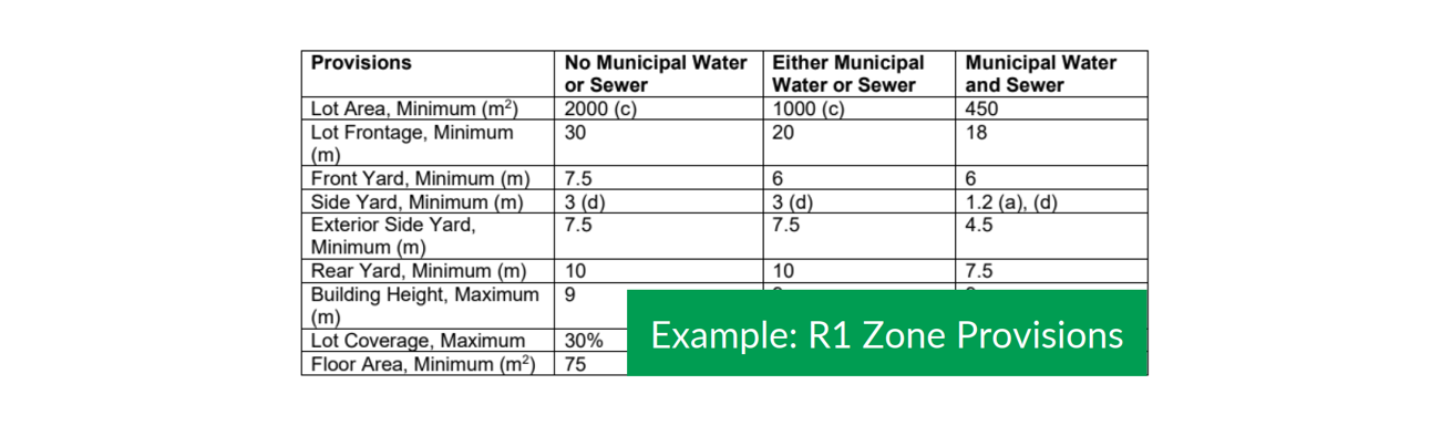
* Once you figure out what your property is zoned, you can check the Zoning By-law to see what the required setbacks are by looking at the "zone provisions" table under each of the zone sections.
* Sometimes, properties will have a subzone (i.e.: R2E, denoted by a letter after the zone), there will be a table of "subzone provisions" that sets out the required setbacks.
* Some properties will also have a Special Exception (i.e.: R2-1, denoted by a dash and a number after the zone), there will be a "Special Provisions" section that sets out specific differences to the zone provisions that apply to this property only.
#### **Step 3: Understanding how the required setbacks apply to your property**
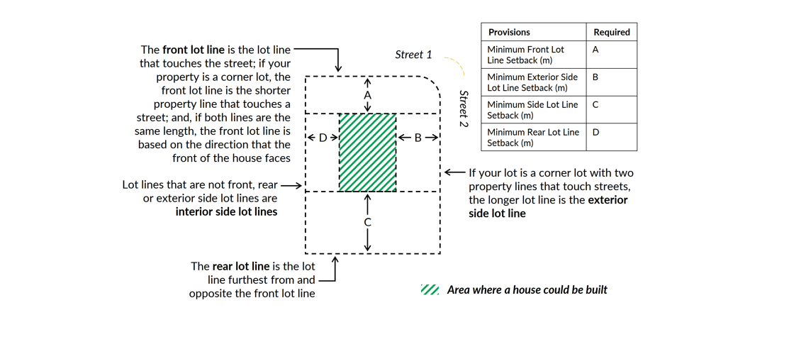
* The setbacks in the zoning by-law are the distances that you must keep between your property lines and the structure that you're building.
* If you are unsure about where your property lines are located, you may need to consult an Ontario Land Surveyor - only Ontario Land Surveyors can tell you exactly where your property lines are located.
* If your yard is larger than the required yard, your deck or porch can be bigger; only the required yards matter.
#### **Environmental and Contextual Notes:**
* In some cases, there may be environmental constraints that would prohibit the construction of buildings in certain locations or there may be additional approvals from the Mississippi Valley Conservation Authority that are required.
* Please note that on some properties, there may be easements, drainage easements, swales or other drainage features that may limit where decks and porches can be located; contact the Municipality if there are features on your property that you are unsure about.
**Development Services
Planning and Engineering Department**
Almonte Old Town Hall
14 Bridge St, PO Box 400
Almonte ON, K0A1A0
[email protected]
613-256-2064
HOURS OF OPERATION
Monday to Friday, 8:30 a.m. to 4:30 p.m.
except on Statutory Holidays
Development Services and Engineering
Click on a button below to visit the other departmental webpages under the Development Services and Engineering department:


Sign up to our newsfeed
Stay up to date on the municipality's activities, events, programs and operations by subscribing to our daily news digest
Sign Up Today!